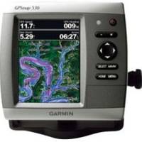
GPSMAP 536 - Marine Chartplotter - 5" color - 480 x 640
Model: 536 Brand: Garmin
The GPSMAP 536 is a compact chartplotter that features a high-resolution, super-bright 5" VGA color display along with an improved high-speed digital design for increased map drawing and panning speeds. It's ready to go with a built-in, satellite-enhanced basemap and an easy-to-use interface designed to help you navigate the open waters with ease. The GPSMAP 536 also accepts BlueChart g2 Vision cards for added features and functionality such as high-resolution satellite imagery, 3-D views and Auto Guidance technology. The GPSMAP 536 has a worldwide basemap with satellite images in place of more traditional maps. The GPSMAP 536 also comes standard with a high-sensitivity GPS receiver for superior satellite tracking and quicker acquisition times. With an SD card slot, it's easy to add additional maps without connecting to a computer. The GPSMAP 536 is also NMEA 2000-certified for easy connectivity with sensors, instruments and future marine offerings. « less
Product Specification
-
General
Product Type: ChartplotterRecommended Use: MarineCard Reader: SD Memory CardInterface: NMEA 0183, NMEA 2000Functions & Services: Tide TabIncluded Software: MapSource BlueChart Inland Lakes: United StatesCompatible Software: BlueChart g2 VisionFeatures: Optional external GPS antenna connection, XM weather supportFirst Seen On Google Shopping: February 2011 -
Display
Type: LCD - colorDiagonal Size: 5"Resolution: 480 x 640 -
Navigation
Waypoints: 3000Tracks: 50Tracklog Points: 20000Routes: 100Trip Computer: Sun/moon positions -
Miscellaneous
Protection: WaterproofWaterproof Standard: IPX7Included Accessories: Protective cover, mounting bracket, power/data cable -
Dimensions & Weight
Width: 5.9 inDepth: 2.9 inHeight: 6.4 inWeight: 1.8 lbs -
Universal Product Identifiers
Part Numbers: 010-00773-00, 536GTIN: 00753759096137
Related Products
-
6 Inch Power Radar Mount for 4' JRC Open Array PMA-6JO-8L ( PMA-57-M1 + ADA-R1)
-
Target Detection by Marine Radar [Book]
-
T70047 E97 Multifunction Display w/Sonar - US Inland Charts
-
GMR 24 4KW Digital Radar Scanner
-
1964CNT NavNet VX2 10.4quot;COLOR Disp 25KW Gearbox
-
ChartKit Book w/ Companion CD - Southern and Centra Map
-
BlueChart g2 Vision - St. Lawrence Seaway - Maps
-
010-C0924-20 Bluechart G2 HXAW005RThe Gulf & Red Sea Microsd/sd
-
Standard HX370S Hand Held VHF - HX370S
-
GP230 3 Intrument Uncut (Replaces NP2003)
-
Cat6a Ethernet Cable | 15ft | White | Network | 10 Gigabit
-
GPSMAP 3010c - Marine GPS receiver - 10.4" color - 640 x 480