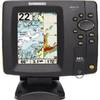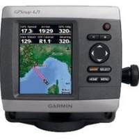
GPSMAP 421 - Marine Chartplotter - 4" color - 240 x 320
Model: 421 Brand: Garmin
The GPSMAP 421 is a compact chart plotter that features an ultra-bright 4" QVGA color display along with an improved high-speed digital design for increased map drawing and panning speeds. It's ready to go with a built-in, satellite-enhanced worldwide basemap and an easy-to-use interface designed to help you navigate the open waters with ease. « less
Product Specification
-
General
Product Type: ChartplotterRecommended Use: MarineCard Reader: SD Memory CardInterface: NMEA 0183, NMEA 2000Included Software: Garmin Worldwide Marine BasemapCompatible Software: BlueChart g2 VisionAntenna: Built-inFeatures: Optional external GPS antenna connection, alarm, automatic routingFirst Seen On Google Shopping: October 2009 -
Display
Type: LCD - colorDiagonal Size: 4"Resolution: 240 x 320Features: Adjustable brightness -
Navigation
Waypoints: 3000Tracks: 50Tracklog Points: 10000Routes: 100Trip Computer: Sun/moon positions -
Miscellaneous
Protection: WaterproofWaterproof Standard: IPX7Included Accessories: Protective cover, power/data cable, flush mount -
Dimensions & Weight
Width: 5.7 inDepth: 2.7 inHeight: 5 inWeight: 1.3 lbs -
Universal Product Identifiers
Part Numbers: 010-00764-00, 421, GPSMAP421GTIN: 00753759095857
Related Products
-
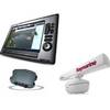
Package(E140W, GPS Antenna, DSM300G Sounder, RA1048D 4KW 48 Inch HD Digital Open Array Radar & 15m Radar Cable )
-
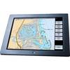
LCX-113C HD - Marine Chartplotter - 10.4" color - 800 x 600
-
Colormax Wide 7" LCD Colormax Wide External CW15873
-
Package(c127 with aus, NZ, S. America, Asia Chart, 4KW 18 Inch Digital Radome & Radar Cable)
-
GPS 72H - Marine, hiking GPS receiver - Monochrome - 120 x 160
-
500 Series 587ci Combo - Marine Chartplotter - 4.5" color - 240 x 320
-
AP2802VRF Autopilot AP28,AC42,RC42 No Drive Unit
-
GB40 15 Inch Glass Bridge Navigation System (Requires GPS Antenna)
-
70M Double 360 Degree White Navigation Light
-
25ft RG6 (18AWG) 75OHM, Quad Shield, CL2 Coaxial Cable with F Type Connector - White
-
743 HPDB50 M/CN50 M SCSI Cable , 25pr - 1.5ft
-
RINO 520HCx - Hiking GPS receiver / two-way radio - Color - 176 x 220