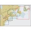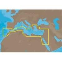
EM-M112 C-Card Format Aegean Sea
Model: EM-M112 Brand: C-Map
South Mediterranean Sea and Aegean Sea: Greece to entrance of Sea of Marmara (partial coverage). SW Turkey, Syria, Lebanon, Israel, Egypt (including Suez Canal and Gulf of Aqaba) Libya and Saudi Arabia. Red Sea coverage ends south of Jeddah, Saudi Arabia. Coverage of the Mediterranean coast of Africa including Egypt, Libya, Tunisia, Algeria to Agadir, Morocco. Also covers the SW coast of Sicily, The southern tip of Sardinia and parts of Southern Spain from Adra to Sines, Portugal. « less
Product Specification
-
Universal Product Identifiers
Part Number: EM-M112C-CARD
Related Products
-
Musician's Gear Bag Black
-
GPSMAP 720 GPS Chartplotter with Internal GPS Antenna 010-00835-00
-
Elite 5 DSI - Fishfinder - included transducer : Skimmer DSI
-
Waterproof Chart Kit - Long Island Sound #WPB0325-03
-
NT Cape COD/LI/HUD River NAC302
-
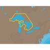
NA-C101 C-Card Format - Superior, Huron, No Chan Grgn
-
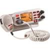
Mr F75-D Marine Class-D Digital Selective Calling Technolog
-
Cat6a Ethernet Cable | 3ft | Gray | Network | 10 Gigabit
-
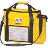
2273 ACR Rapidditch,#153 Express Bag - Bouyant Abandon Ship Survival G
-
Low Profile Wall Mount Bracket for LCD LED Plasma (Max 165Lbs, 30~63inch) - Silver
-
20ft 24AWG Cat6 550mhz UTP Ethernet Bare Copper Network Cable - Black
-
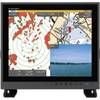
MU190HD 19 Inch Color LCD Marine Monitor