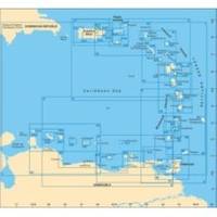
D232 Imray Curacao Marine Nautical Chart
Model: D232 Brand: Weems And Plath
This Imray-Iolaire waterproof chart details the island of Curacao. It includes large scale insets of Willemstad and Schottegat Piscaderabaai Santa Marta Baai and Spaanse Water. This color chart is flat with no folds so is suitable for framing. Dimensions: 25 x 35 1/2 (640 x 900 cm). « less
Product Specification
-
Universal Product Identifiers
Part Number: D232
Related Products
-
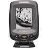
PiranhaMAX 180 - Fishfinder - included transducer : XNT-9-QB-90-T - triple-beam
-
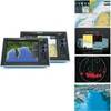
G10 10" Mfd W/2KW Sonar 408020-1
-
Inc MSD/652P Map, Lake Huron
-
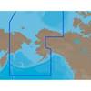
NA-C804 C-Card Format Northern Alaska
-
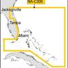
NT Plus Wide Chart N-NA-C306 Bahamas
-
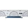
120 Marine Navigation Parallel Plotter
-
5500 Series LED All Around Navigation Lights 60" Straight Pole
-
743 HPDB50 M/CN50 M SCSI Cable , 25pr - 1.5ft
-
Split Connector 40ft Right Angle RJ45 Plug
-
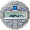
MC20 - Marine Remote Commander w/LCD Display
-
MARE-005 - Adapter, Raymarine E-Series > Micro Male
-
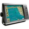
GPSMAP 4212 - Marine Chartplotter - 12.1" color - 1024 x 768