Chapman Nautical Chart No. 1: The Essential Guide to Chart Reading and Navigation [Book]
The essential reference tool for reading maps, published by the Coast Guard, is now available to boaters in an attractive, colorful edition that includes important supplementary information about navigation. A must-have for all mariners, the first half of the manual reproduces the U.S. Coast Guard book, with coverage of basic chart concepts, the anatomy of a chart, how to read a chart, symbols and abbreviations associated with National Ocean Service and Defense Mapping Agency charts, and the chart numbering system. In addition, for extra value, the USCG version has been expanded to include navigation tips and techniques from Chapman Piloting and Seamanship, 64th edition, including details on positioning procedures, dead reckoning, and river piloting. « less
Product Specification
-
Authors: John Wooldridge, John Wooldridge United States Coast Guard United States Coast GuardPages: 201Format: paperbackPublication Date: October 1, 2004Key Terms: daybeacons, Notices to Mariners, nautical charts, nautical miles, racon, IALA, Light Lists, compass rose, Radar, statute miles, U.S. Coast Guard, Morse Code, trom, chart datum, Loran-C, Anchorage, World Geodetic System, GEOGRAPHIC COORDINATES, Degaussing, Cape Hatteras
-
Universal Product Identifiers
ISBN: 1588164004GTIN: 09781588164001
Related Products
-
Commander Color Display with SSRC1 Rate Gyro Compass & Rotary Feedback 10110034
-
JFE380 6 Inch Color LCD Sonar with Nkf341 Transducer and Matching Box
-
IR2 4.4 4KW 4.5 Foot Open Array Radar R-0006
-
Package(e127 with USA Coastal Chart, 4KW 24 Inch Digital Radome & Radar Cable)
-
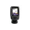
Fishfinder echo 300c - Fishfinder - included transducer - dual-beam
-
GP1041 Pre-Cut F/ Raymarine C70 & One ST60 Instrument
-
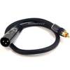
1.5ft Premier Series XLR Male to RCA Male 16AWG Cable (Gold
-
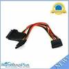
5184 0.2meter 15pin SATA Power Y Cable
-
35ft Premium Optical Toslink Cable w/ Metal Fancy Connector
-
Cat6a Ethernet Cable | 1ft | White | Network | 10 Gigabit
-
Corp mdl T Connector ILMDL-T
-
Automatic Generator Start 809-0915 (Require Scp System) C16523