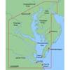
BlueChart g2 Vision - Southwest Florida - Maps
Model: Brand: Garmin
BlueChart g2 Vision offers the same rich detailed charting of BlueChart g2 to help you get the most out of your unit. In addition, g2 Vision features a growing database of high-resolution satellite imagery, above and below the water 3D perspective, auto guidance technology, aerial photographs for real world reference and coastal roads with points of interest. This product features crystal River through Key Largo, including Tampa Bay, Ft. Myers, Lake Okeechobee, Florida Bay, Key West, and the Dry Tortugas. « less
Product Specification
-
General
Product Type: MapsDistribution Media: SD Memory CardFirst Seen On Google Shopping: May 2007 -
Compatibility Information
Designed For: Garmin GPSMAP 4008, 4012, 420, 4208, 420s, 4212, 430, 430s, 430sx, 430x, 440, 440s, 440sx, 440x, 450, 5008, 5012, 520, 5208, 520s, 5212, 525, 525s, 530, 530s, 535, 535s, 540, 540s, 545, 545s, 550, 550s, 555, 555s -
Universal Product Identifiers
Part Numbers: 010-C0712-00, Southwest FloridaGTIN: 00753759068929
Related Products
-
ICE 45 - Fishfinder - portable - included transducer : XI 9 19 - dual-beam
-
T70045 E97 Multifunction Display w/Sonar - Row Charts
-
Radar 4008 Package with GMR18 4KW Radome
-
FR8252 Color 12.1 Inch LCD 25 KW 96Nm Radar without Antenna
-
T92181 RD418D 4KW 18 Inch Dome with Cable
-
MapSource BlueChart - Chesapeake - Maps
-
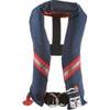
1230nav-00-000 Classic Seriesflotation Vest Nylon Univ Navy
-
Cat6a Ethernet Cable | 35ft | White | Network | 10 Gigabit
-
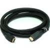
6ft 24AWG CL2 High Speed HDMI Cable w/ Net Jacket - Black
-
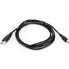
6ft USB A to Mini-B 5pin 28/28AWG Cable
-
120-53 EP-80RTH Thru-Hull Water Temperature Sensor
-
TM258-8F 1kW 50/200 kHz Transom Mount Transducer 8F Connector