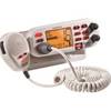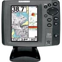
700 Series 757c Combo CHO - Marine Chartplotter - 5" color - 240 x 320
Model: 757c Brand: Humminbird
The 757c Combo CHO features a brilliant color 320V x 240H 5" display, dual beam plus sonar with 4000 watts PTP power output, GPS Chartplotting with built-in UniMap, and advanced fishing system capabilities.
Product Specification
-
General
Product Type: ChartplotterRecommended Use: MarineFunctions & Services: SpeedCompatible Software: Navionics Gold, Navionics HotMaps PremiumFirst Seen On Google Shopping: March 2008 -
Display
Type: TFT - colorDiagonal Size: 5"Resolution: 240 x 320Display Illumination: YesFeatures: Split screen zoom, Real Time Sonar (RTS) window, TrueArch, sonar echo enhancement, Selective Fish ID+, sonar recording -
Transducer
Transducer Presence: Optional transducerTransducer Type: Dual-beamTransducer Mount: Transom, in-hullMaximum Depth: 1500 ftTarget Separation: 2.5 inBeamwidth: 20/60 degreesOperating Frequency: 83/200 kHzPower Output (Peak to Peak): 4000 WPower Output (RMS): 500 WTransducer Features: Built-in temperature sensor -
Navigation
Waypoints: 3000Tracks: 50Tracklog Points: 20000Routes: 50 -
Power
Low Voltage Power: DC 10 - 20 V -
Miscellaneous
Protection: Waterproof -
Dimensions & Weight
Width: 6.9 inDepth: 4.5 inHeight: 7.5 in -
Universal Product Identifiers
Part Numbers: 406750-1CHO, 757c Combo CHOGTIN: 00082324031359
Related Products
-
Commander P2 Mono Display, SSRC1 Rate Gyro Compass & Rotary Feedback 10110031
-
858c Di GPS/Fishfinder Combo 42463
-
E70022 E97 Multifunction Display w/Sonar - No Charts
-
Fishfinder echo 100 - Fishfinder - included transducer
-
FR8062 12.1 Inch 6KW, 72 nm, 12.1 Color Display Radar 6' Open Array Antenna fr80626
-
Mr F75-D Marine Class-D Digital Selective Calling Technolog
-
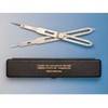
4548 Marine Navigation Proportional Divider
-
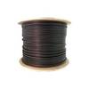
Bulk cable - CAT 6 - 1000 ft - Black
-
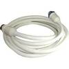
50 Amp 50' Cord Set - White - 125/250V
-
15ft 32AWG Mini DisplayPort to DVI Cable - White
-
100ft Premium Optical Toslink Cable w/ Metal Fancy Connector
-
Fiber Optic Cable, LC/LC, Multi Mode, Duplex - 1 Meter 6202