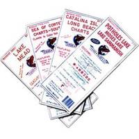
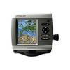
4125 Map -San Diego/Ensenada
Model: 4125 Brand: Fish-n-Map
FISH-N-MAP UNDERWATER TOPOGRAPHY MAPSMade of waterproof, tear resistant plastic. Features include: underwater depth contours, fish locations, latitude and longitude for GPS, multiple freshwater lakes on one map, boat ramps, recreational facilities and much more.
Product Specification
-
Universal Product Identifiers
Part Numbers: 4125, 7101066GTIN: 00761428041258
Related Products
-
UM415 Oceanus D Marine Radio (White)
-
Series 43 White LED Navigation Light Port
-
Zeus Sailing Navigation System - 8 in Display 000-10239-001 c43561
-
5040SS1 Stainless Pulsar Nav. Lights
-
75ft 24AWG Cat5e 350MHz UTP Bare Copper Ethernet Network Cable - White
-
3ft 32AWG Mini DisplayPort Male to Female Extension Cable - White
-
Kensington Bluetooth USB Micro Adapter Network adapter - USB
-
Patch cable - CAT 6 - RJ-45 - M - Unshielded twisted pair (UTP) 14 ft - Gray
-
CPA-138 Cell Phone Adapter Cable
-
Cat6a Ethernet Cable | 75ft | Black | Network | 10 Gigabit
-
GPSMAP 536s - Marine Chartplotter - 5" color - 480 x 640
-
GPSMAP 420s - Marine GPS receiver - 4" color - 240 x 320
