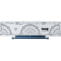
120 Marine Navigation Parallel Plotter
Model: 120 Brand: Weems And Plath
Our most popular plotter! This instrument consists of a plotter mounted on a roller. The plotter contains distance scales at 1:20 000 1:40 000 and 1:80 000 to fit the N.O.S. Coast and Harbor Charts as well as an inch scale. Included are a semi-circular protractor for measuring courses and bearings against a meridian on the chart and two quarter circle protractors for measuring courses and bearings against a parallel of latitude. Courses and parallel lines are transferred and kept parallel by means of two rollers which are mounted on a slide axis. Used for measuring or laying off courses and distances on a nautical chart. Instructions included. Dims: 3.5 x 12.5 . « less
Product Specification
-
Universal Product Identifiers
Part Numbers: 120, DEF-803231GTIN: 00721002001207
Related Products
-
Ci68BB Black Box Doppler Sonar Current Indicator
-
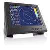
NSS8 Navigation Pack - NSS8 3G Radar
-
Popular Atlases, Gulf Islands Atlas Canadian Charts
-
BlueChart g2 Vision - Aegean Sea and Sea of Marmara - Maps
-
Canadian Charts Qu.Charlot Str.W.Portion/Bull Harb.
-
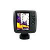
Fishfinder echo 550c - Fishfinder - included transducer - dual-beam
-
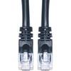
Cat6a Ethernet Cable | 5ft | Black | Network | 10 Gigabit
-
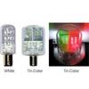
2nm Tricolor Masthead Nav Bulb LED
-
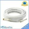
25ft 24AWG CL2 Standard HDMI Cable - White
-
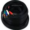
35ft 22AWG 5-rca Component Video/audio Coaxial Cable (RG-59/U) - Black
-
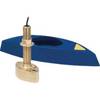
B45-DO-RCA 600W Thru-Hull Transducer RCA Connector
-
PiranhaMAX 215 - Fishfinder - included transducer : XNT-9-20-T - dual-beam