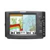
010-C1025-20 Bluechart G2 HXEU718LMediterranean Sea Microsd/sd
Model: 010-C1025-20 Brand: Garmin
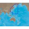
See your surroundings more clearly with BlueChart g2 data. With BlueChart g2, you’ll get detailed marine cartography that provides convenient viewing of nautical content. BlueChart g2 allows you to see your vessel’s precise, on-chart position in relation to naviads, coastal features, anchorages, obstructions, waterways, restricted areas and more. You will also have access to detailed mapping capabilities that include Safety Shading, Fishing Charts, smooth data transition between zoom levels, harmonious transition across chart borders, and reduction of chart discontinuities. Covers: Detailed offshore coastal coverage of the Mediterranean Sea in its entirety. Coverage features the Strait of Gibraltar, the Balearic Islands, the French Riviera, Corsica, Sardinia, Sicily, the Adriatic Sea, the Greek Islands, the Aegean Sea, the Dardanelles and Bosporus Straits, the Sea of Marmara, Cyprus, the Suez Canal, Tripoli and Algiers Harbors, and the Gulfs of Gab « less
Product Specification
-
Universal Product Identifiers
Part Numbers: 010-C1025-20, 10807295, 35822GTIN: 00753759096250
Related Products
-
385 Rudder Position Indicator
-
1100 Series 1157c Combo - Fishfinder - included transducer : XNT-9-20-T - dual-beam
-
NA-C701 Furuno FP Format Olympia Wa - Port Mcneill BC
-
AN-M001 SD Card Format East China Sea & Kamchatka
-
010-C1024-20 Bluechart G2 HXUS401SBermuda Microsd/sd Adaptor
-
Cat6a Ethernet Cable | 15ft | Blue | Network | 10 Gigabit
-
30 Amp 50' Cord Set - Yellow - 125V
-
2110 50ft 24AWG CL2 Standard HDMI Cable - Black
-
OPC-1000 20' Cable
-
TNCM-58-G TNC Type Male Connector for RG-58X Coax
-
HBL26CM13 30A Female Connector
-
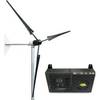
Whisper Marine Wind Turbine Whi-200 Marine with Controller