010-C0924-20 Bluechart G2 HXAW005RThe Gulf & Red Sea Microsd/sd
Model: 010-C0924-20 Brand: Garmin
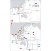
HXAW005R Covers: Coverage of the Arabian Penninsula beginning at the Mediterranean Sea from Beirut to Alexandria. Coverage includes the Suez Canal, Gulf of Aqaba, and the Red Sea and Gulf of Aden in their entirety. Includes the Strait of Hormuz, Gulf of Oman, and coast of Somalia in the south. Coverage the of Kuwait, Saudi Arabia, Qatar, United Arab Emirates, along the southern coast of the Gulf and Iran along the northern coast. Coverage of Yemen and Oman coasts along the Indian Ocean to the Gulf of Oman, including Pakistan along the north coast, with general coverage of the Arabian Sea from Qamar Bay to the Delta of the Indus River. Included in this overall general coverage are numerous detailed charts covering areas such as Alexandria, Egy., Beirut, Leb., Al-Fuhaihil, Ad- Dammam, Bahrain, Ad-Dauha, and Abu Dhabi. Jiddah, Sau., Djibouti, Dji., and Aden, Yem. « less
Product Specification
-
Universal Product Identifiers
Part Numbers: 010-C0924-20, 10807154, 35798GTIN: 00753759093280
Related Products
-
NAVPILOT 500 Navigational Autopilot with Heading Sensor - No PU
-
JMA-5332-12 Radar 96 NM with 12' Open Array & 19 Inch LCD Monitor
-
BlueChart g2 Vision - Southern Gulf of Mexico - Maps
-
BlueChart g2 Vision - Yellow Sea - Maps
-
Max AU-M207 W61 Papua New Guinea-MAX
-
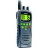
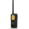
T42554 Atlantis Hand-Held VHF 2-Way Marine Radio - Black
-
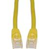
Cat6a Ethernet Cable | 15ft | Yellow | Network | 10 Gigabit
-
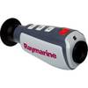
E70033 TH32 320 x 240 Thermal Marine Scope
-
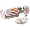
Mr F55-D Fixed Mount Class D VHF Radio - White 40519
-
DB9 Male / DB25 Male, 9c, 6 ft Molded (UL)
-
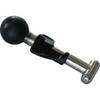
Ram 1" Connector - TM00506
-
000-10217-001 - VHF-HH/GPS Combo, HH33U