010-C0878-10 Bluechart G2 HAE003RTaiwan Data Card
Model: 010-C0878-10 Brand: Garmin
Covers mainland China from Macau to Shanghai, the Taiwanese coast in its entirety, and the Babuyan Islands to the south. Included in this overall general coverage are a number of detailed charts covering areas such as Chi-Lung, Tai., Kao-Hsiung, Tai., Shanghai, Chi., Xiamen, Chi., Guangzhou, Chi., and Hong Kong. See your surroundings more clearly with BlueChart g2 data. With BlueChart g2, you'll get detailed marine cartography that provides convenient viewing of nautical content. BlueChart g2 allows you to see your vessel's precise, on-chart position in relation to naviads, coastal features, anchorages, obstructions, waterways, restricted areas and more. You will also have access to detailed mapping capabilities that include Safety Shading , Fishing Charts , smooth data transition between zoom levels, harmonious transition across chart borders, and reduction of chart discontinuities. « less
Product Specification
-
Universal Product Identifiers
Part Numbers: 010-C0878-10, 10807014, 35777GTIN: 00753759090036
Related Products
-
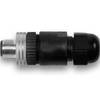
010-11094-00 NMEA 2K Male Connector
-
E102143 CP450C ClearPulse Chirp Sonar
-
Package(C120W, RA1072HD 4KW 72 Inch HD Digital Open Array Radar & 15m Radar Cable)
-
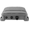
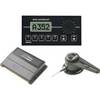
22096366 - Control Head for AP28
-
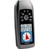
GPSMAP 78s - Marine, hiking GPS receiver - 2.6" color - 160 x 240
-
AP35 Autopilot System AP35, J3000X, RF300 No Heading Sensor
-
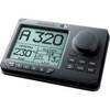
RD33 4. 3 in. Color LCD Navigational Data Organizer
-
25ft RG6 (18AWG) 75OHM, Quad Shield, CL2 Coaxial Cable with F Type Connector - Black
-
Trident Marine LPG Propane Gas Remote Regulator Connector
-
2201 Black Terminal Feed Through Connector
-
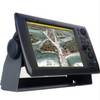
NavNet 3D Color 12.1" LCD Multifunction Display
-
lian B3-I3DN i3 System Dish Network All-in-One Package w/Multi-Sa