010-C0763-10 Bluechart G2 HEU004RIrish Sea Data Card
Model: 010-C0763-10 Brand: Garmin
British coast: covers from Port Ellen on the Isle of Islay to Falmouth, including the Isle of Man and the Isles of Scilly. Irish coast: covers from Sheep Haven to Caherciveen, Republic of Ireland, including Londonderry, The Storks, Belfast, and Dublin. See your surroundings more clearly with BlueChart g2 data. With BlueChart g2, you'll get detailed marine cartography that provides convenient viewing of nautical content. BlueChart g2 allows you to see your vessel's precise, on-chart position in relation to naviads, coastal features, anchorages, obstructions, waterways, restricted areas and more. You will also have access to detailed mapping capabilities that include Safety Shading , Fishing Charts , smooth data transition between zoom levels, harmonious transition across chart borders, and reduction of chart discontinuities. « less
Product Specification
-
Universal Product Identifiers
Part Numbers: 010-C0763-10, 10804839, 35599GTIN: 00753759091491
Related Products
-
000-00099-007 - Sst-dfsblk, LSS-1
-
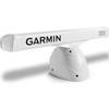
Pedestal for Gmr404 & 406 Arrays Arrays, 20 1/2"W x 12 3/4"H
-
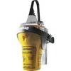
EPIRB with GPS Auto Release Cat I EG50 Auto c30587
-
Smarterchart SC500A 5 Inch Chartplotter with AIS
-
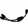
Marine Twisted-Pair Y-Adapter Cable - XMD-WHTAIC1F2M
-
PP118DP Push Plug for 1-1/8 & 1-1/4
-
18-8804-1 Premium Marine Spark Plug Wire Leads
-
TracVision R6DX System w/ Multiservice Box Only Dish 32911
-
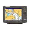
GPSMAP 740 - Marine Chartplotter - 7" color - 800 x 480 - widescreen
-
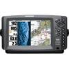
GlobalMap 9300C HD - Marine GPS receiver - 10.4" color - 600 x 800
-
408720-1 998c HD Si Combo
-
2842 Globalfix Pro 406 EPIRB Integral GPS - Category 1