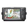
010-C0752-10 Bluechart G2 HAF452SKnysna Sa to Beira MZ Data
Model: 010-C0752-10 Brand: Garmin
Coverage of the southeastern coast of Africa from Mossel Bay, S. Af. to the mouth of the Zambezi River. Detailed coverage includes Port Elizabeth and Durban, S. Af., Maputo, Moz., as well as the Prince Edward Islands. See your surroundings more clearly with BlueChart g2 data. With BlueChart g2, you'll get detailed marine cartography that provides convenient viewing of nautical content. BlueChart g2 allows you to see your vessel's precise, on-chart position in relation to naviads, coastal features, anchorages, obstructions, waterways, restricted areas and more. You will also have access to detailed mapping capabilities that include Safety Shading , Fishing Charts , smooth data transition between zoom levels, harmonious transition across chart borders, and reduction of chart discontinuities. « less
Product Specification
-
Universal Product Identifiers
Part Numbers: 010-C0752-10, 10804656, 35585GTIN: 00753759089733
Related Products
-
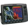
HDS 10 Base Sonar / Chartplotter US 83/200kHz 140-00
-
Sonar X-100c, X105cdf, X-136df, X-135, X-126DF, X-125, X67C Sonar [DVD]
-
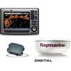
Package(E90W, GPS Antenna, DSM300G Sounder, 4KW 18 Inch Digital Radome & Radar Cable )
-
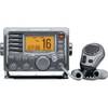
m504a-63 Submersible Plus Class D DSC VHF Marine Radio Gray
-
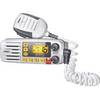
Solara DSC Fixed Mount VHF 2-Way Marine Radio White
-
408690-1 958c HD Combo
-
4155 Ferrite cores (1 Pair) for 24AWG HDMI Cable
-
18inch SATA Data and Power Combo Cable - Silver
-
Serial cable - (DB-9) - M - 15 ft - PC
-
252130 Butt Connector #8 HD 2/pk
-
Terk Sirmarine Satellite Radio Antenna
-
Eclipse DSC+ Fixed Mount VHF, Eclipse DSC 25W VHF Fixed Black