010-C0748-10 Bluechart G2 HAF002RSouth Africa Data Card
Model: 010-C0748-10 Brand: Garmin
Detailed coverage of the coast of southern Africa from Namibe, Ang. to Angoche, Moz., including the South African cities of Cape Town and Port Elizabeth. Includes detailed coverage of Durban S. Af. and Maputo, Moz. Also includes detailed coverage of the Tristan da Cunha Group, the island of St. Helena, and the Prince Edward Islands. See your surroundings more clearly with BlueChart g2 data. With BlueChart g2, you'll get detailed marine cartography that provides convenient viewing of nautical content. BlueChart g2 allows you to see your vessel's precise, on-chart position in relation to naviads, coastal features, anchorages, obstructions, waterways, restricted areas and more. You will also have access to detailed mapping capabilities that include Safety Shading , Fishing Charts , smooth data transition between zoom levels, harmonious transition across chart borders, and reduction of chart discontinuities. « less
Product Specification
-
Universal Product Identifiers
Part Numbers: 010-C0748-10, 10804557, 35577GTIN: 00753759089658
Related Products
-
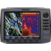
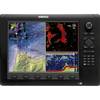
HDS-10 No Transducer - 140-41
-
Max Wide International cwidei
-
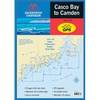
Waterproof Chart Book - Casco Bay to Camden 35266
-
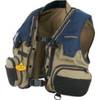
PFD 33 Gram Manual Inflatable Chest Pak in Navy Size: Small / Medium
-
000-10345-001 - NSE12 Navigation Pack
-
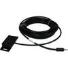
TM200-30 Temperature Probe f/SST-110 TM
-
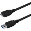
USB 3.0 Micro Cable | 3ft | Type A | Micro Type B | Black
-
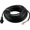
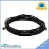
010-11418-00 - 10M Marine Heading Sensor Cable NMEA0183
-
2832 35ft Optical Toslink 5.0mm OD Audio Cable
-
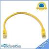
1ft 24AWG Cat5e 350MHz UTP Bare Copper Ethernet Network Cable - Yellow
-
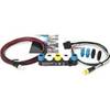
E22158 SeaTalk 1 to SeaTalk NG Converter Kit
-
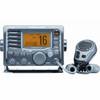
M504 Grey VHF Radio